
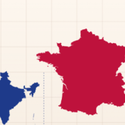
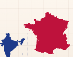







Size It Up: Geography turns country outlines into a visual scale-estimation challenge. Instead of identifying a country by name or locating it on a map, the player sees its real outline beside a fixed scale reference and has to decide how large that landmass actually is. There is no story, campaign, or character progression. Each round is a separate geography puzzle based on the true east-west or north-south extent of the country or territory shown.
Reading the Country Outline
The outline begins at an adjustable size, while the reference remains fixed. The player can drag the country around the board and resize it until its proportions seem correct compared with the scale bar. Geography uses real country and territory outlines rather than simplified icons, so familiar shapes can still be difficult when they are removed from a normal world map. The category currently contains 219 silhouettes.
Controls and Scoring
A round follows a simple sequence:
- inspect the country outline and scale reference;
- drag the silhouette into a useful position;
- resize it with corner handles, the mouse wheel, or pinch controls;
- use arrow keys for small position adjustments;
- use + and − for smaller scale changes;
- press Lock in when the estimate is ready;
- compare the guess with the true measurement.
After locking in, the correct outline is displayed over the player’s version. Red shows that the guess was too large, while blue shows that it was too small. The score is based on proportional error, so being twice too large is treated the same as being half the correct size. A guess within about 6% earns 100 points, while larger errors gradually reduce the score.
Geography Progression
Size It Up: Geography does not contain traditional numbered levels. The category can be played repeatedly on its own, while geography puzzles can also appear as part of the daily Size It Up set. Past daily sets remain available separately, and category play can continue without affecting the daily streak.
Playing well requires thinking about real dimensions rather than how large a country looks on a familiar map projection. Long narrow countries can be especially misleading, while compact countries may seem larger than expected when shown alone. The best approach is to compare the outline directly with the scale reference, identify whether the measured axis is east-west or north-south, and make small adjustments before locking in the final answer.
